SEAMLESS-WAVE

SEAMLESS-WAVE is a developing “SoftwarE infrAstructure for Multi-purpose fLood modElling at variouS scaleS” based on "WAVElets" and their versatile properties. The vision behind SEAMLESS-WAVE is to produce an intelligent and holistic modelling framework, which can drastically reduce iterations in building and testing for an optimal model setting, and in controlling the propagation of model-error due to scaling effects and of uncertainty due statistical inputs.
Preparing the initial conditions files for ACC/FV1 on QGIS
The Merewether test case has a pond at its end near the downstream boundary. The pond is associated with a constant free-surface elevation of h + z = 17.8 m, which needs to be considered as an initial condition. LISFLOOD-FP expects to read such an initial condition as an Esri ASCII raster file, which is made of either free-surface elevation (h + z) or water depth (h) data, with the extension of .start (recall “Input files and their format”).
To generate the raster file for the initial free-surface elevation, the following steps must be applied in QGIS:
- Load the Merewether DEM raster file, named
merewether-0p175m.demin QGIS (recall “Viewing the DEM data on QGIS”). - Go to the menu Raster - > Raster Calculator
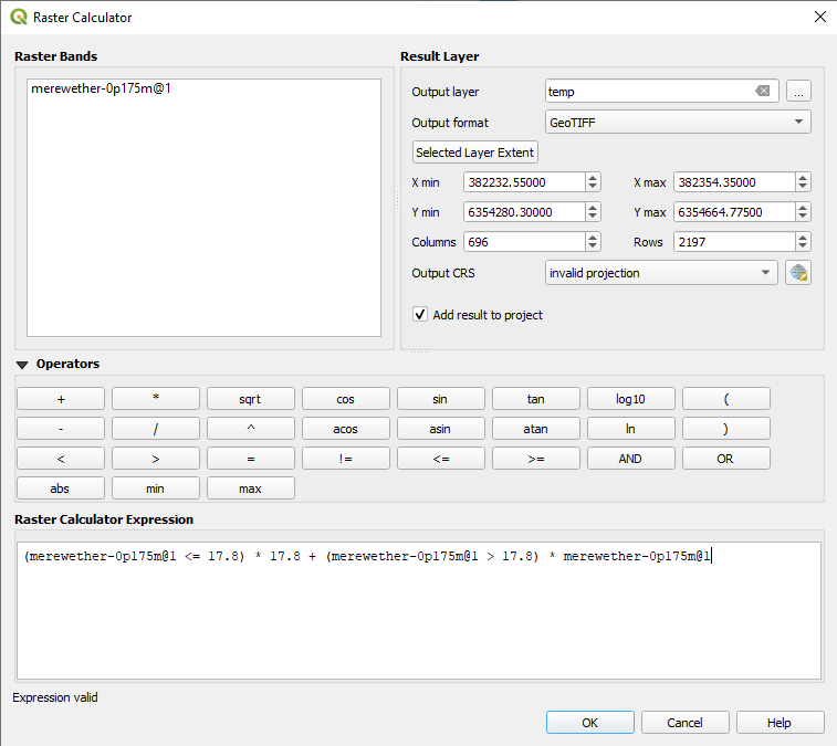
- In the Raster Calculator window, enter the following expression in Raster Calculator Expression:
(merewether-0p175m@1 <= 17.8) * 17.8 + (merewether-0p175m@1 > 17.8) * merewether-0p175m@1 - Enter a name, e.g.
temp, for the new layer in the Output layer section (see figure below). This puts a value of 17.8 for the free-surface elevation (h + z) in all areas where the topography (z) value is below 17.8, while the other portions remain unchanged as they are dry areas.
- To convert the newly created
templayer into a raster format readable by LISFLOOD-FP, select it in the Layers window and go to menu Raster - > Conversion - > Translate (Convert Format). - In the Translate (Convert Format) window, set Assign a specified nodata value to output bands as -9999 and click on Save to File…
- Save the file with
.ascextension, for example under the same name introduced before, for convenience, i.e.merewether-0p175m.asc. - Once saved, change the extension of file from
.ascto.start.
After applying these steps, the free-surface elevation raster file, merewether-0p175m.start can be read by LISFLOOD-FP (recall “Input files and their format”).
Generating the initial water depth (h) raster file follows the same steps above, whereby the following expression should be entered in the Raster Calculator window:
(merewether-0p175m@1 > 17.8) * 0 + (merewether-0p175m@1 <= 17.8) * (17.8 - merewether-0p175m@1)
This puts zero values for the water depth (h) in areas where the topography is higher than 17.8 (dry areas) and retains the depth value as it is, otherwise.