SEAMLESS-WAVE

SEAMLESS-WAVE is a developing “SoftwarE infrAstructure for Multi-purpose fLood modElling at variouS scaleS” based on "WAVElets" and their versatile properties. The vision behind SEAMLESS-WAVE is to produce an intelligent and holistic modelling framework, which can drastically reduce iterations in building and testing for an optimal model setting, and in controlling the propagation of model-error due to scaling effects and of uncertainty due statistical inputs.
Digital Elevation Model file (.dem)
This file contains the topographical data or digital elevation model (DEM) which also defines the extent and the resolution of the computational grid. The file must be in Esri ASCII raster format, which contains the first six rows as header section followed by a space-delimited 2D array of numerical values defining the data points on the computational grid. An example screenshot of the file format is shown below.
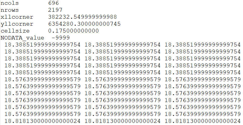
The header section contains the following information:
-
ncols. Number of cell columns (i.e. number of computational cells in X direction) -
nrows. Number of cell rows (i.e. number of computational cells in Y direction) -
xllcorner. X coordinate of the lower left corner of the computational 2D domain in metres -
yllcorner. Y coordinate of the lower left corner of the computational 2D domain in metres -
cellsize. Cell size in metres (modelling resolution for square computational cells) -
NODATA_value. Null value (Default is -9999)
Though this file can be manually edited using any simple text editor, it is advised to use QGIS, a geographic information system platform, to visualise or manipulate the DEM data file.
QGIS is freely available to download and an example of how to use it to visualise and manipulate the DEM data file for the Merewether case study is provided in “Preparing the input data”.